File:Lagrange B.jpg

Original file (2,400 × 2,100 pixels, file size: 709 KB, MIME type: image/jpeg)
Lagrange points with force contour lines.
Lagrange points 1-5 of the Sun-Earth system
Diagram of the Lagrange Point gravitational forces associated with the Sun-Earth system. WMAP orbits around L2, which is about 1.5 million km from the Earth. Lagrange Points are positions in space where the gravitational forces of a two body system like the Sun and the Earth produce enhanced regions of attraction and repulsion. The forces at L2 tend to keep WMAP aligned on the Sun-Earth axis, but requires course correction to keep the spacecraft from moving toward or away from the Earth.
Note: Image is not to scale
http://map.gsfc.nasa.gov/m_ig/ig_mission3.html
http://map.gsfc.nasa.gov/m_mm/ob_techorbit1.html
| This file is in the public domain because it was created by NASA. NASA copyright policy states that "NASA material is not protected by copyright unless noted". (NASA copyright policy page or JPL Image Use Policy).
Warnings:
|
File history
Click on a date/time to view the file as it appeared at that time.
| Date/Time | Thumbnail | Dimensions | User | Comment | |
|---|---|---|---|---|---|
| current | 04:17, 12 April 2007 | | 2,400 × 2,100 (709 KB) | Mdelaney (talk | contribs) | Lagrange points 1-5 of the Sun-Earth system Diagram of the Lagrange Point gravitational forces associated with the Sun-Earth system. WMAP orbits around L2, which is about 1.5 million km from the Earth. Lagrange Points are positions in space where the gra |
| 12:20, 8 March 2007 | 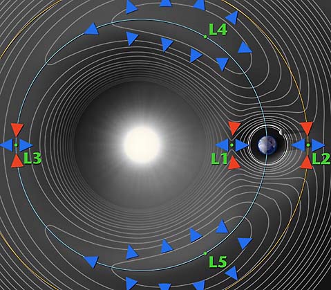 | 479 × 419 (49 KB) | Jarogers2001 (talk | contribs) | Lagrange points with force contour lines. [http://map.gsfc.nasa.gov/m_mm/ob_techorbit1.html http://map.gsfc.nasa.gov/m_mm/ob_techorbit1.html] {{PD}} |
You cannot overwrite this file.
File usage
The following 2 pages use this file:


